SLR and LiDAR: Solutions for High-Precision Remote Sensing

Introduction to Satellite Laser Ranging (SLR) and Light Detection and Ranging (LiDAR)
Light Detection and Ranging (LiDAR) and Satellite Laser Ranging (SLR) are laser-based remote sensing techniques that have become essential across many areas of science and engineering, spanning geodesy, Earth observation, topographic mapping, forestry, urban modelling, and autonomous systems. The development of pulsed laser sources and precise timing electronics made it possible to measure the time of flight (TOF, ) of a laser pulse reflected off a remote object with high accuracy, and convert it to distance using the speed of light c and the factor to account for the round-trip path.
First proposed in 1930 by E. H. Synge as a light-based probe of the atmosphere, LiDAR has evolved into airborne and terrestrial systems that emit rapid laser pulses, measure their time-of-flight, and turn returns into georeferenced 3D points. The scanning pattern yields dense point clouds that distinguish ground, vegetation, and built structures, enabling topographic mapping, surface-change monitoring, infrastructure modelling, and autonomous-system perception 1.
SLR followed a different path. Early experiments at NASA in the 1960s demonstrated its feasibility over short distances before extending the method to orbiting satellites 2. Modern SLR systems rely on ultrafast, low-jitter timing electronics to achieve millimetre-level ranging for geodetic and space-science missions 3. In SLR, laser pulses are sent from ground stations to satellites equipped with retroreflectors. Beyond measuring distance, this technique is essential for various measurements, such as defining the International Terrestrial Reference Frame (ITRF), studying Earth’s gravity variations, and calibrating satellite missions.
While the mission objectives and operating scales of SLR and LiDAR differ, they both rely on highly accurate, stable, and fast timing electronics to deliver consistent, high-quality results under demanding conditions.
The key differences between SLR and LiDAR are highlighted in Table 1 4:
| Feature | Satellite Laser Ranging (SLR) | Light Detection and Ranging (LiDAR) |
|---|---|---|
| Primary Application | Tracking satellite positions for geodesy and orbit determination | Topographic mapping, vegetation analysis, and infrastructure modeling |
| Range | Extremely long distances (up to 20,000 km) | Short to moderate range (up to a few kilometers from airborne/ground) |
| Measurement Purpose | Monitoring Earth’s shape, rotation, and gravitational field | Creating detailed 3D models of surface features |
| Platform | Ground-based observatories shooting lasers at orbiting satellites | Aircraft shooting lasers at objects on earth, ground vehicles (autonomous driving cars) |
The differences between SLR and LiDAR become even clearer when looking at practical applications. In satellite laser ranging, ocean-altimetry missions use ground-based laser ranging to refine precise orbit determination for global sea-level studies.
In LiDAR, improved TOF precision at the detector and timing-electronics level leads to more precise distance estimation of remote objects 5.
The Role of Timing Electronics and Time-Correlated Single Photon Counting for SLR and LiDAR
Typical setups for SLR and LiDAR measurements are represented in Figure 1 above. In both cases, the transmitter emits short laser pulses; after kilometre-scale propagation and path losses, the return at the receiver is typically in the photon-counting regime (mean detected photons per shot much smaller than one). A single-photon detector, Single Photon Avalanche Diode (SPAD), Avalanche Photodiode (APD), Superconducting Nanowire Single-Photon Detector (SNSPD), or Photomultiplier Tube (PMT) in photon-counting mode, converts each detected photon into an electrical pulse, which the time-to-digital converter time-stamps for TOF estimation.
A digital pulse generator orchestrates the experiment: it triggers the laser, opens/closes detector gates, and provides the start signal for the TOF measurement, while detector pulses provide one or more stop events. The TOF is then calculated using the start signal and one or multiple stop signals. The generated timestamps are then transferred from the TDC to the computer, where the data evaluation occurs.
In SLR, the approximate target distance is known a priori, so the detector is range-gated, which means it is only enabled when the echo is expected. A typical measurement result is depicted in Figure 2a, where a satellite is tracked over several seconds, and a higher density of the point cloud is visible at the satellite distance within the measured range.
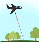
In LiDAR, the TDC records all stops within a window after each start (until the next laser pulse). Aggregating many shots yields a multi-stop histogram versus TOF (or distance): distinct peaks correspond to surfaces of high reflectivity (e.g., canopy, ground, water) as depicted in Fig. 2b. The intensity dip at short times is caused by the detector and timing electronics’ dead time1. The achievable range resolution associated with the width of the peaks is set by the instrument response function (IRF): a convolution of laser pulse width, detector jitter, and TDC timing jitter.

The different timing parameters affecting the measurement precision are summarized in Table 2.
| Timing Parameter | Influence on Measurement Result |
|---|---|
| Shorter Laser Pulse Width (typ. Tens of ps) | Better Distance Resolution (typ. ~mm) |
| Lower Laser Pulse Repetition Rate (typ. kHz (ms)) | Larger Target distance (SLR)/Unambiguous measurement range (LiDAR) (typ. ~km) |
| Lower TDC & Detector Timing Jitter (typ. ~10ps/ 100ps to ns) | Better Distance Resolution (typ. mm-cm) |
| Lower TDC & Detector Dead Time (typ. ns) | Higher Signal Dynamic Range & Linearity |
Common Challenges in Laser Ranging and Requirements for the Timing Electronics and Signal Generator
The setup parameters listed in Table 2 pose high demands on the timing electronics in order to achieve millimeter precision in SLR and LiDAR measurements, and the conventional timing electronics often introduce several challenges in terms of:
Timing Jitter. To achieve millimetre-class ranging, the TDC’s intrinsic jitter must be in the few-picosecond regime so it does not add appreciable error to the TOF estimate (rule of thumb: 1 ps corresponds roughly 0.15 mm one-way distance). Since detectors typically have a higher cost-to-performance ratio, ensuring that the TDC contribution to the system timing jitter is only a percentage of the detector’s contribution is efficient.
Dead Time Dead time should be comparable to or shorter than the detector’s recovery time (typically nanoseconds) so that no detector clicks are missed and results are not distorted at high count rates, keeping multi-stop histograms accurate over the full dynamic range.
Data Transfer Rate Requirements. Photon-counting LiDAR can produce high aggregate event rates. SLR generally has much lower average rates, but narrow range gates and bursty returns still demand stable TDC internal buffering to avoid dropped timestamps during the acceptance window. Both regimes, therefore, place stringent requirements on sustained, lossless data transfer between the TDC and the computer to prevent dropped timestamps and biased range statistics.
Data Handling and Analysis. Conventional timing systems often write in bursty file dumps with limited buffering and little real-time histogramming or TOF fitting. At higher event rates, these risks dropped timestamps and pauses for I/O, which biases processing and validation. Calibration, gate timing, and clock metadata are frequently stored in separate logs, making runs hard to reproduce and re-analyze easily. This extends development cycles, increases operational costs, and reduces adaptability in fast-evolving research or industrial environments.
Experiment Orchestration of Complex Experiments. Conventional timing stacks rarely offer a single control plane to coordinate laser triggers, detector gating/range windows, scanner, and TDC acquisition. SLR and LiDAR require digital pulse generators with high resolution, low jitter, and synchronized multi-channel outputs to control all the components and ensure reproducibility reliably.
Swabian Instruments’ Time Tagger and Pulse Streamer - an advanced solution for SLR and LiDAR
Swabian Instruments’ Time Taggers and the Pulse Streamer 8/2 offer a robust, high-performance solution for demanding LiDAR and SLR applications. Unlike conventional timing systems, the Time Taggers combine exceptional precision with usability, delivering high-resolution timestamping and real-time data access, all with low system complexity and minimal overhead. In parallel, the Pulse Streamer enables precise and programmable control of digital and analog output signals, making it ideal for synchronizing laser pulses and gating detectors with nanosecond-level resolution.
Why SLR and LiDAR measurements benefit from the Pulse Streamer 8/2:
High Timing Precision: High Timing Precision achieved with digital pulse patterns offering less than 50 ps RMS timing jitter and 1 ns-resolution. These features are key to controlling pulsed laser systems and orchestrating the SLR and LiDAR experiments.
Ease of Implementation and ability to quickly design digital patterns and analog waveforms of any complexity using intuitive encoding facilitates the implementation process.
Native Libraries and a dedicated GUI enable seamless experiment control. Further, Swabian Instruments provides a Pulse Streamer GUI for testing purposes and programming of simple pulse patterns.
Synchronous Operation guaranteed from the outset as digital and analog outputs remain fully synchronized, eliminating the need for cross-device timing adjustments.
Flexible Placement is permitted through Ethernet connectivity, which allows control from any location and enables flexible device positioning.
Why SLR and LiDAR measurements benefit from the Swabian Instruments’ Time Tagger:
High Timing Resolution: The low instrument jitter, down to 1.5 ps RMS, allows for approximately 0.2 mm-ranging error and measurement resolution. To date, the timing jitter of commercially available detectors is at least an order of magnitude larger. As a result, the overall instrument response function (IRF) is primarily detector-limited rather than TDC-limited.
Short Dead Time: A short dead time of 1.5 ns in the Time Tagger X supports multi-hit operation and makes it faster than commercially available single photon detectors in the market, ensuring that closely spaced photon detections are captured and no events are missed.
High Data Rate: High data rates of up to 90 Mtags/s over USB 3.0 to the computer and up to 1.2 Gtags/s over QSFP+ to a secondary FPGA enable continuous real-time acquisition and processing of large events.
Powerful Software Engine: A powerful Software Development Kit (SDK) with predefined measurement classes, comprehensive documentation, and tutorials streamlines experiments. The acquired time tags are streamed to the computer, where multiple measurements can run simultaneously on the same data (e.g., histogram count rate, TOF fitting) either via Application Programming Interface (API in Matlab, Python, LabView, C++, etc.) or via the Graphical User Interface (GUI) TimeTaggerLab.
Maximum System Flexibility: This results in measurements running independently using any combination of input channels. Data can be taken simultaneously from independent physical setups, with multiple measurements running on the same channels.
Results in SLR and LiDAR applications with Swabian Instruments’ systems
Swabian Instruments provides a comprehensive, compact, and software-friendly solution by offering both the Time Tagger and Pulse Streamer 8/2, each designed to meet the rigorous demands of time-critical experiments.
Some examples of real-world implementation include:
Dr. Daniel Hampf’s team at the German Aerospace Center demonstrated a miniSLR system of low cost, high-performance, combining Swabian Instruments Time Tagger Ultra Performance and two Pulse Streamers 8/2. The Time Tagger was used to record timestamps, including start, stop, PPS, laser trigger, and detector gate signals. The Pulse Streamers generated signals for laser triggers (steady PPS-aligned 50 kHz trigger sequence) and detector gate (dynamically calculated based on the expected TOF of the target)6.
Adrian Abazi from the University of Münster has been working on an SNSPD-based LiDAR system using Swabian Instruments’ Time Tagger X for minimal timing jitter. He achieved a total system jitter of 11 ps and demonstrated stable sub-millimeter ranging, highlighting the potential of this approach for next-generation LiDAR imaging and quantum sensing applications 5. For more information, please check Adrian Abazi’s LiDAR Application Note and Success Story.
Wherever measurement precision depends on stability, resolution, and synchronization, Swabian Instruments products deliver the necessary hardware-level assurances for exact data acquisition, including low jitter, stable delay paths, and traceable timing. Together, these tools eliminate traditional bottlenecks in development and experimentation by combining precise time measurement with robust control. Whether in space geodesy or real-time spatial mapping, this integrated platform offers a reliable foundation for advanced laser ranging and time-resolved measurement applications.
Application notes
Time of Flight Light Detection and Ranging (ToF LiDAR)
ToF-LiDAR-Adrian-Abazi-(Uni-Münster).pdfCustomer success stories
Adrian Abazi, Uni Münster
In terms of usability, it’s very nice, and the documentation is clear and helpful. The software examples made it easy for me to build on and create user interfaces for my colleagues, so they could perform the experiments more easily.
Read more


A. Wehr and U. Lohr, “Airborne laser scanning—an introduction and overview,” ISPRS J. Photogramm. Remote Sens., vol. 54, no. 2–3, pp. 68–82, July 1999, doi: 10.1016/s0924-2716(99)00011-8. ↩︎ ↩︎
Z. Elizabeth, “How Satellite Laser Ranging Got its Start 50 Years Ago.” [Online]. ↩︎
M. R. Pearlman, J. J. Degnan, and J. M. Bosworth, “The International Laser Ranging Service,” Adv. Space Res., vol. 30, no. 2, pp. 135–143, July 2002, doi: 10.1016/s0273-1177(02)00277-6. ↩︎
“Millimeter accuracy satellite laser ranging: A review,” in Geodynamics Series, Washington, D. C.: American Geophysical Union, 1993, pp. 133–162, doi: 10.1029/gd025p0133. ↩︎
A. S. Abazi, R. Jaha, C. A. Graham-Scott, W. H. P. Pernice, and C. Schuck, “Multiphoton enhanced resolution for superconducting nanowire single-photon detector-based time-of-flight lidar systems,” Phys. Rev. Res., vol. 7, no. 3, p. 033114, Aug. 2025, doi: 10.1103/sv4y-qps6. ↩︎ ↩︎
D. Hampf, F. Niebler, T. Meyer, W. Rieder, The miniSLR: a low-budget, high-performance satellite laser ranging ground station. J Geod 98, 8, Jan. 2024, doi: 10.1007/s00190-023-01814-1 ↩︎